Finding Home
"...In that Empire, the Art of Cartography attained such Perfection that the map of a single Province occupied the entirety of a city, and the map of the Empire, the entirety of a Province." From "On Exactitude in Science" by Borges
Early maps of the world contribute much to deep sea dragon hunting and not a lot else, as far as modern wayfinding goes. Like if you want to get to California by some early cartographers' maps, you'd have to go by boat--California was depicted as an island in the Pacific--sailing very close to the Garden of Eden. Watch for dragons, and mind the grumpy marginalia between Earth and chaos, it disturbs unless sacrificed to. Apropos it may be for the state founded by opportunism and known for raunchy artifice to appear on maps so near the site of original sin (filmed on location at low transportation cost!), but it's little more than a coincidence among myths.
On the Typus Orbis map, the standard world map from 1540 to 1570, wind-blowing heads surround the world's land as in Homer's Odyssey, on which the depiction was based. (At some point in their journey back to Ithaca, Homer's crew untie the bag of wind given to them by King Aeolus, letting out a wind that blows them ashore of an unknown island.)

Plenty of maps from the Mediterranean regions show winds symbolized by heads or windbags, and given how important wind was to sea travel, it isn't too surprising that cartographers would reference myth and legend in their schemas: the map had to be accurate to documented reality and supplicatory before chance, making it both tool and talisman.

The idea that a map should be usable by anyone, should overcome limitations of language and relative orientation, is one that's unique to our time and place. Marshall Island mapmakers constructed maps out of sticks, strings and shells to memorize ocean swell patterns and islands' locations before leaving by boat for a journey.
Often these maps could be interpreted only by the mapmaker, who, having memorized his map, would be the primary navigator for the trip. Rather than consult a map during the trip, he would rely on memory and a sense of how the water moved honed by lying on the bottom of the boat to feel its pitches and rolls.* This sort of tactile training, seen and experienced after much practice, can look and feel like "intuition," a conflation that's both easy to mock and venerable as a synthetic, much like polyester (which I learned is often used to make boat hulls).
Echolocation is another technique that's a rare deviation from our reliance on one sense--sight--to navigate. Bats, whales and dolphins use it regularly; the blind can be trained to use it to find a course among objects. This is done by emitting a clicking sound with the tongue (or using a device that makes a clicking sound) and interpreting the sound waves that return. I talked with a man who'd been blind since birth and relied on echolocation to get around in the city; he said that different cities obviously sound very different (some, like Boston, have lots of buildings made of heavy stones, some are often snow-covered, some have lots of glass-covered buildings) and that he'd developed "sound maps" of areas he frequently traveled, which made it easy to know when familiar objects on his route had changed. He remembered these maps the way you'd remember a song, and each place's song was a mnemonic that encapsulated not only information about objects' locations, but also his own dispositions in each place, with favorite places' sounds being of course more pleasing.
Plenty of research disagrees about how we go about wayfinding. Do we perform complex computations, summing vectors and optimizing manifold possible routes? Do we memorize sequences of images? Do we store whole maps, or do we store route information more abstractly, and in more than one physical place in our brains? None of these questions have been answered without being challenged almost immediately by contradictory evidence; a few simple observations about wayfinding techniques will have to suffice, as far as answers go: wayfinding techniques include dead reckoning (estimating your position based on the distance you've traveled in your current direction from your previous position), using a map and compass, echolocation, astronomical positioning, and the latest fad, global positioning.

The Global Positioning System (GPS) was developed by the US Department of Defense, and it consists of a number of satellites orbiting Earth. Very simply, how it works is this: a satellite sends a signal to your GPS device (which is basically a receiver for said signals) and it measures the time delay between when the satellite sent the signal and when you received it. It multiplies this time by the speed of light, and it compares this to the satellite's location, which the satellite occasionally sends the receiver. Using position and range, the receiver can determine its own position. And satellite images are also useful for wayfinding: Google maps and google earth are two fine examples of how nice it is to augment meager human wayfinding abilities with our more formidable abilities to develop sense and memory extending technologies.
And these super-accurate maps render superfluous the "Here there be dragons"
commonly written on ancient maps' uncharted regions. We've gone from murk and darkness and monsters to very precise representations of what's really out there, making the old maps and myths obvious allegories for our fears of the unknown--which isn't to say that these have been rendered superfluous. They'll just be a little more private, the echoes, songs and mnemonics that make the murk and darkness of even the most well-documented places more familiar.
*Maps' importance (or lack of) as political documents is apparent: that the Marshall Islanders didn't carry maps to show expectant royalty or patrons newly conquered territory at least suggests that their sea travels were motivated by different goals than were those of early Europeans.
Early maps of the world contribute much to deep sea dragon hunting and not a lot else, as far as modern wayfinding goes. Like if you want to get to California by some early cartographers' maps, you'd have to go by boat--California was depicted as an island in the Pacific--sailing very close to the Garden of Eden. Watch for dragons, and mind the grumpy marginalia between Earth and chaos, it disturbs unless sacrificed to. Apropos it may be for the state founded by opportunism and known for raunchy artifice to appear on maps so near the site of original sin (filmed on location at low transportation cost!), but it's little more than a coincidence among myths.
On the Typus Orbis map, the standard world map from 1540 to 1570, wind-blowing heads surround the world's land as in Homer's Odyssey, on which the depiction was based. (At some point in their journey back to Ithaca, Homer's crew untie the bag of wind given to them by King Aeolus, letting out a wind that blows them ashore of an unknown island.)
The Typus Orbis world map, popular from 1540-1570
Plenty of maps from the Mediterranean regions show winds symbolized by heads or windbags, and given how important wind was to sea travel, it isn't too surprising that cartographers would reference myth and legend in their schemas: the map had to be accurate to documented reality and supplicatory before chance, making it both tool and talisman.
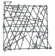
The idea that a map should be usable by anyone, should overcome limitations of language and relative orientation, is one that's unique to our time and place. Marshall Island mapmakers constructed maps out of sticks, strings and shells to memorize ocean swell patterns and islands' locations before leaving by boat for a journey.
A stick map used by Marshall Island navigators
Often these maps could be interpreted only by the mapmaker, who, having memorized his map, would be the primary navigator for the trip. Rather than consult a map during the trip, he would rely on memory and a sense of how the water moved honed by lying on the bottom of the boat to feel its pitches and rolls.* This sort of tactile training, seen and experienced after much practice, can look and feel like "intuition," a conflation that's both easy to mock and venerable as a synthetic, much like polyester (which I learned is often used to make boat hulls).
Echolocation is another technique that's a rare deviation from our reliance on one sense--sight--to navigate. Bats, whales and dolphins use it regularly; the blind can be trained to use it to find a course among objects. This is done by emitting a clicking sound with the tongue (or using a device that makes a clicking sound) and interpreting the sound waves that return. I talked with a man who'd been blind since birth and relied on echolocation to get around in the city; he said that different cities obviously sound very different (some, like Boston, have lots of buildings made of heavy stones, some are often snow-covered, some have lots of glass-covered buildings) and that he'd developed "sound maps" of areas he frequently traveled, which made it easy to know when familiar objects on his route had changed. He remembered these maps the way you'd remember a song, and each place's song was a mnemonic that encapsulated not only information about objects' locations, but also his own dispositions in each place, with favorite places' sounds being of course more pleasing.
Plenty of research disagrees about how we go about wayfinding. Do we perform complex computations, summing vectors and optimizing manifold possible routes? Do we memorize sequences of images? Do we store whole maps, or do we store route information more abstractly, and in more than one physical place in our brains? None of these questions have been answered without being challenged almost immediately by contradictory evidence; a few simple observations about wayfinding techniques will have to suffice, as far as answers go: wayfinding techniques include dead reckoning (estimating your position based on the distance you've traveled in your current direction from your previous position), using a map and compass, echolocation, astronomical positioning, and the latest fad, global positioning.
Those aren't the four winds in the corners, they're satellites.
The Global Positioning System (GPS) was developed by the US Department of Defense, and it consists of a number of satellites orbiting Earth. Very simply, how it works is this: a satellite sends a signal to your GPS device (which is basically a receiver for said signals) and it measures the time delay between when the satellite sent the signal and when you received it. It multiplies this time by the speed of light, and it compares this to the satellite's location, which the satellite occasionally sends the receiver. Using position and range, the receiver can determine its own position. And satellite images are also useful for wayfinding: Google maps and google earth are two fine examples of how nice it is to augment meager human wayfinding abilities with our more formidable abilities to develop sense and memory extending technologies.
And these super-accurate maps render superfluous the "Here there be dragons"
commonly written on ancient maps' uncharted regions. We've gone from murk and darkness and monsters to very precise representations of what's really out there, making the old maps and myths obvious allegories for our fears of the unknown--which isn't to say that these have been rendered superfluous. They'll just be a little more private, the echoes, songs and mnemonics that make the murk and darkness of even the most well-documented places more familiar.
*Maps' importance (or lack of) as political documents is apparent: that the Marshall Islanders didn't carry maps to show expectant royalty or patrons newly conquered territory at least suggests that their sea travels were motivated by different goals than were those of early Europeans.
posted by evelyn at 3:31 PM
![]()
![]()


0 Comments:
Post a Comment
<< Home